Code Green Solutions


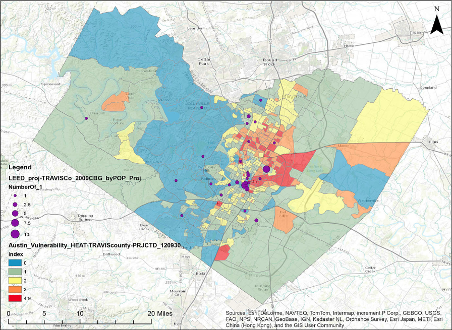
Number of LEED Certified Projects in Travis County (2001-2012) Overlaid on Austin Heat Vulnerability Index
Extreme weather events such as heat waves and floods do not affect everyone equally. Some populations are more at risk than others of disease, injury, and death because of the unique combination of social, economic, demographic, and environmental characteristics of the neighborhoods where they live, work, and play.
With the health effects of extreme weather and other climatic events on the rise, it is becoming increasingly important for project teams to perform a localized vulnerability assessment of the site early in the design process (preferably during the Visioning or Schematic Design phase), so that the final project supports the long-term health of building occupants and the surrounding community.
GBIG can be used by projects located in high-risk neighborhoods to identify case studies of other local projects that have achieved a set of LEED credits offering the opportunity to reduce the negative health effects of climate change.
How to Determine Your Site’s Localized Vulnerability to Climatic Events
A site’s localized vulnerability to climate change is comprised of two components:
STEP 1: Identify the top 2-3 climatic hazards to which your city or town is at highest risk of exposure. Resources for this step (in order of priority) include:
STEP 2: Identify climate change vulnerability maps of your city or county.
Vulnerability maps have been developed for several climate change-related extreme weather events, including heat waves, flooding, sea level rise, and hurricanes. Be sure to look for maps that are downscaled to at least the Census Tract or Zip Code level. Maps that provide resolution down to the Census Block Group level (roughly equivalent to the neighborhood scale) are particularly useful for small- to medium-size cities and for areas with dramatic variations in landscape.
Examples of local climate change vulnerability maps that include both social and built environment characteristics include:
Prioritizing Green Building Strategies that Enhance Localized Resilience to Climatic Events
A review of the public health literature on extreme heat and flooding events found that the following LEED credits offer the opportunity to reduce a neighborhood’s vulnerability to climatic events in two ways:
The list of green building strategies enhancing resilience changes from one climatic events to the next. For example, providing access to multiple forms of transportation (SSc4) can help populations in flooded areas evacuate, whereas increasing insulation to reduce a building’s energy load (EAc1) can enhance its passive survivability during a heat event.
The table below displays the results of the literature review. The supporting research will be made available on this blog after publication.
GBIG Climate + Health Resilience Collections
As a first step towards making climate change vulnerability assessments available to all green building design teams, GBIG has launched Climate + Health Resilience Collections for Heat Passive Survivability, Flood Passive Survivability, Flood Exposure, and Heat Exposure in Austin, TX.
The projects included in these collections have achieved the full set of the LEED credits identified by the literature review as offering the possibility of reducing a neighborhood’s vulnerability to climatic events.
Applications to Design
Project teams in Austin can now use the vulnerability maps listed above to determine whether or not their project is located in a vulnerable neighborhood. If it is, they can model their approach to enhancing resilience on the LEED certified projects in the Climate + Health Resilience Collections.
By building awareness about the role green building design can play in reducing localized vulnerability to climate change, these new collections can be used to spark coordinated efforts among property owners, designers, and the surrounding community to increase neighborhood resilience to climatic events.